La Sal Mountains, Part 1
My ass thanked me for a sitting on a rock (albeit, a fake one) that didn't cause major pelvic discomfort within 45 seconds. I spent the better part of the day before teeter-tottering over acres of splintered and sliding granite and now my cheeks planted firmly and evenly on one of the artificial slabs acting as a bench outside work. It was Monday and I was uffering from withdrawal and lack of focus brought on by yesterday's dehydration, an over-syruped gas station Mocha and the receding exhaustion of my 3 day backpacking trip in the La Sal Mountains. Now, staring at Mt. Olympus, a minor but popular peak in the metropolitan playground of the Wasatch, I began to appreciate the unique experience Lexi and I concluded 24 hours earlier.
 |
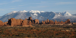
| The La Sal Mountains create an incredible backdrop for the redrock of Moab. |
Less than 15 miles east of Moab, the peaks of the Sierra La Sal create the almost too perfect background scenery to Eastern Utah's Arches and Canyonlands' National Parks. If the redrock monuments and canyons aren't enough to create the feel of an old western movie, then the snowcapped peaks in the distance will certainly make you question whether or not the landscape is real or just a canvas ready to be wheeled off as soon as filming is done for the day.
The Sawtooth and Wind River Mountains were two destinations Lexi and I considered when trying to figure out what to do for a weekend in late August. However, aside from the guilt of alienating our home state's numerous mountain ranges once again, I dreaded the 6+ hour travel time to each of those places; so something within Utah was preferable. True, the Uintas were closer, yet there we could be sure of two swarms of pests: mosquitoes and Boy Scouts. The option of the La Sals seemed perfectly convenient while also being a new, unexplored territory for us. So on a hot Friday afternoon, we headed 250 miles southeast to Moab where I felt pretty confident a majority of the tourists would be sweating it out at the National Parks rather than venturing up into the 2nd highest mountain range in Utah.
That Friday evening, we ended our travel for the day by pulling into the Oowah Lake Campground, 4 miles removed from the La Sal Mountain Loop Road and at about 9,000' in elevation. With more open campsites than occupied campsites, this small, forested lake nestled between Haystack Mountain and Boren Mesa felt like the perfect place to camp for the night. Being my first time in these mountains, a basecamp seemed comforting as opposed to rushing out onto the trail while evening approached. Plus, I still wasn't certain where we would go. Partly due to the small area the range covers, there isn't much in multi-day backpacking options. And unlike the Uintas, the La Sals are crisscrossed by roads and lack any “wilderness” designation. I worried we might find this alpine oasis in the desert sort of tame. In fact, the base of most of the peaks are easily approached by driving and most trip reports on summitpost.org said the various 12,000' peaks climbed within a day. While studying the solid and dotted lines on the crammed contours of my map, I looked for a route we could hike away from the road that led us to a peak which we could climb. I chose Mt. Mellenthin as a destination. Second highest in the range, it's approach began south at Geyser Pass. Geyser Pass could be hiked to on a dotted line (non-motorized) through the romantic sounding Moonlight Meadows. I thought we might be able to climb the peak and still make it back to Moonlight Meadows that night for camp. And if not, we had other opportunities to explore, such as the trail that headed into the heart of the mountains on the north side of the range. And while the presence of a road took some of the escapism out of our trip, it did provide a nice crutch should we need a fast, obvious route back to Oowah Lake.
Saturday morning, I got up around 8am, giving the sun as much time as possible to work it's way up over the mountains and through the thick trees that surrounded us. Without much exposure to the sun, the ground still had the damp remains of yesterday's rain shower and it felt strange to think that in the lowlands below us, any moisture that fell would have been baked away on that Navajo sandstone in a matter of minutes. While stretching my back, a rustling in the bushes across the road caught my attention. My mind raced to assign a source to the grunting and suddenly the orange signs around camp warning of bears became more profound. While black bears tend to be more nuisance than danger, I have gladly managed to avoid crossing paths with them on all my backpacking trips, so suddenly the La Sal's presented some “wilderness” in a different way.
 |
| Clark Lake on the trail to Geyser Pass. |
After a quick wipe down of the dishes (not a full-on washing, a bit of chaos acceptance that was out of character for me and applauded by Lexi) we started out on the trail around 10am. Making our way towards Moonlight Meadows and Geyser Pass, our bearing was due east to the divide between the LaSal's two clusters of mountains. In the north cluster were Tomasaki, Manns and Wass and to the south, the big boys: Mellenthin, Tukuhnikivats, Tuk No and the highest in the range, Mt. Peale. All above 12,000' and all are deserving of a Utah peak bagger's attention. While weekend warriors and ill equipped teenagers tread the numerous Wasatch Mountain trails, while backpackers descend on the multi-day sojourns needed to climb the remote Uintas, no one seems to consider the La Sals. Or maybe they do and just choose not to share it because you normally can drive right to the foot of most mountains and be up and down before the day is done? Ease of access aside, Lex and I wanted one more backpacking trip for the summer, especially when it's the best way to camp somewhere memorable. At least that's what I told myself while carrying 50 pounds of gear on my back while listening to the rumble of vehicles driving up and down Geyser Pass road; never more than a mile away.
 |
| Moonlight Meadows in the shadow of (l to r) Mellenthin, Tukuhnikivatz and Tuk No |
After about 2 hours of hiking through the narrow canyon above Oowah Lake, we came into a large meadow dotted with patches of trees and hills that gradually worked it's way up to Geyser Pass. While the map showed plenty of small blue dots, there really wasn't much in the way of lakes, more like ponds, and considering the abundance of cows, I quickly ruled this out as a possible campsite for the night. This was Moonlight Meadows, and while that name may sound romantic, I think a more accurate pronunciation of the name is MOOOOOOnlight Meadows. At first the bovines were quaint company, (I am from Wisconsin after all) but before long, they got annoying. We felt a little intrusive as they stared dumbstruck at us, waiting until the last second to move and bellowing the whole way. The slow moving herd reminded me of the lumbering herds of tourists we might have encountered had we been in Arches that day, with the difference being that, in most cases, tourists aren't literally shitting all over the landscape.
When Lexi and I reached Geyser Pass around 1:30, I reevaluated the feasibility of climbing Mt. Mellenthin that afternoon. It seemed unlikely. We were lunching on ham sandwiches on a damp log just off the road while I studied the map for places we could camp for the evening that would be reachable in the remaining time we had but still far enough from the road so we weren't rubbing elbows with ranchers. Supposedly, there was a faint trail that led through the woods to Mt. Mellenthin, but I wasn't seeing it. However, even without a trail, the route to the base of Mellenthin quite obvious, about a mile straight south through the trees. We could still try reaching the base and climb the peak on Sunday. However, I was concerned about the lack of a water sources around Mellenthin. Fortunately, the temperatures had remained mild most of the day and I estimated we had enough water to get us through to tomorrow. So far, the hike lacked any difficulty, but it also failed, so far, to meet my expectations. Moonlight Meadows was one big cow pie, we took longer to reach Geyser Pass than I thought and we had yet to find a remote, picturesque spot to camp. There were some obvious and easy to find lakes on the east side of the range we could head towards, but hiking down a road to a lake where any Tom, Dick and Harry could get to with a 4WD wasn't my idea of a great backpacking trip. I looked through the trees that separated us from Mellenthin and wondered if we were too bent on bagging a peak rather than having an enjoyable time in the mountains. It's unrealistic to think that the plans you make while studying a map in the comfort of your home, or the images you gain while staring at pictures on the internet will be anything like reality; you have to be flexible. With that in mind, Lexi and I decided we had nothing to lose by trying to make our way to the base of Mellenthin. Should the off trail hiking get to be too toilsome, we still had plenty of daytime to turn back and camp close to Geyser Pass. Even thought we may not be able to climb the summit, venturing to a secluded spot in the shadow of a mountain would still be worthwhile. As we started into the woods, there was some deadfall to circumnavigate, but fortunately, the trees stayed wide and we eventually found a trail. After a mile of gradual hiking through the mossy, damp woods, dotted with bright red mushrooms and other variations of fungus that seemed so out of place in Utah, we came to a clearing below the base of Mellenthin.


Comments